
About Mali
Bambara - now an official language and the most widely spoken, at ~46.3% of the population as a mother tongue.
French - also official, spoken by ~17.2%, a legacy of colonial rule.
Peuhl/Fulfulde, Dogon, Soninke/Maraka, Malinke, Songhai/Djerma, Tamasheq, and Senoufo are also spoken; Mali has 13 national languages in addition to its official languages.
Bambara and French are both official languages of Mali.
| Geography |
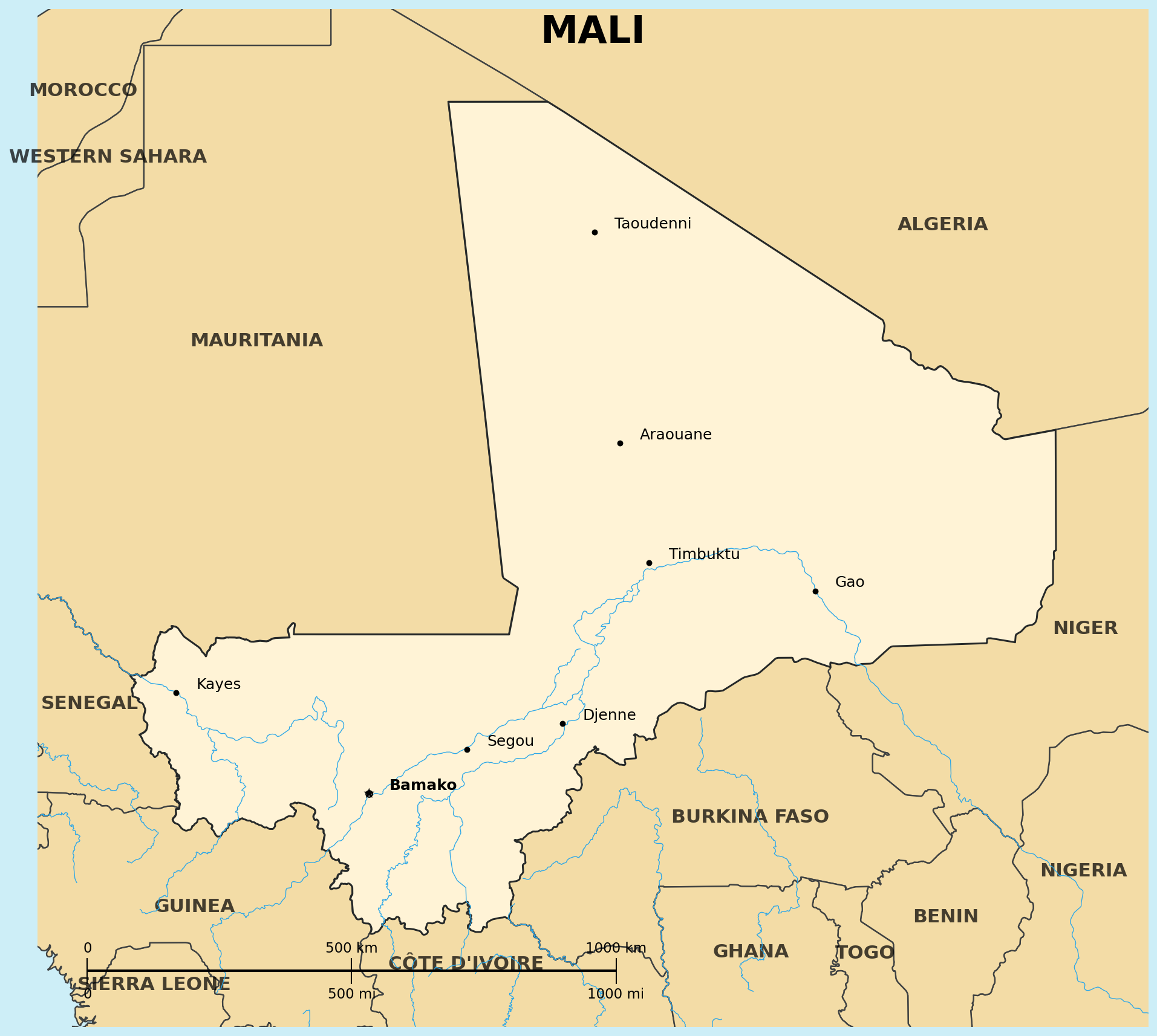
Location: Western Africa, landlocked, southwest of Algeria
Map references: Africa
Area:
total: 1,240,192 sq km; 8th largest country in Africa
Land boundaries:
border countries: Algeria, Burkina Faso, Cote d'Ivoire, Guinea, Mauritania, Niger, Senegal (7 countries)
Terrain: divided into three natural zones: the southern, cultivated Sudanese; the central, semiarid Sahelian; and the northern, arid Saharan
Natural hazards: hot, dust-laden harmattan haze common during dry seasons; recurring droughts; occasional Niger River flooding
| People |
Population: 22.4-25.9 million (2025-2026 est.); expected to double by 2035; total fertility rate of about 6 children per woman, the third highest in the world
Life expectancy at birth: total population 60.4 years (World Bank, 2025)
Nationality:
noun/adjective: Malian(s)
Ethnic groups: Bambara 33.3%, Fulani (Peuhl) 13.3%, Sarakole/Soninke/Marka 9.8%, Senufo/Manianka 9.6%, Malinke 8.8%, Dogon 8.7%, Sonrai 5.9%, Bobo 2.1%, Tuareg/Bella 1.7%, other 6.7% (2018 est.); over 15 ethnic groups
Religions: Muslim 93.9%, Christian 2.8%, Animist 0.7%, none 2.5% (2018 est.)
Languages: Bambara (official) 46.3%, French (official) 17.2%, Peuhl/Foulfoulbe/Fulani 9.4%, Dogon 7.2%, Maraka/Soninke 6.4%, Malinke 5.6%, Sonrhai/Djerma 5.6%, Minianka 4.3%, Tamacheq 3.5%, Senoufo 2.6%, Bobo 2.1%, other 6.3% (2009 est.); 13 national languages in addition to official languages
Literacy: total population 35.5% (male 46.2%, female 25.7%) (2018 est.)
Population distribution: overwhelming majority live in the southern half of the country, with greater density along the border with Burkina Faso; about 10% of the population is nomadic
| Government |
Country name:
conventional short form: Mali; the name derives from the Mali Empire of the 13th-16th centuries AD, possibly from the ethnic group Malinke, whose name derives from ma ("mother") and dink ("child")
Data code: ML
Government type: transitional military government
National capital: Bamako
Independence: 22 September 1960 (from France; the Mali Federation began as the Sudanese Republic and Senegal)
Background: a 2012 political coup slowed Mali's growth; the economy has bounced back since with GDP growth above 5% in some years, though physical insecurity, high population growth, corruption, weak infrastructure, and low human capital continue to constrain development; in 2022 the Economic Community of West African States (ECOWAS) imposed sanctions on the transition government and member states closed their borders with Mali after the transition government presented a five-year timeline for return to civilian rule; formed the Alliance of Sahel States with Burkina Faso and Niger in 2023
| Economy |
Economy - overview: low-income, least-developed West African economy; about 80% of the labor force is engaged in farming and fishing; developing iron ore extraction to diversify foreign exchange earnings away from gold; government subsidizes cereal production to reduce dependence on imported foodstuffs
GDP (purchasing power parity): $72.74 billion (2025 est.)
GDP - real growth rate: 4.9% (2025)
GDP - per capita: $2,930 PPP (2025 est.)
Unemployment rate: 2.8-3.1% (2024-2025)
Currency: West African CFA franc (XOF)